Thursday, August 31, 2023

Reflections Lake

 I decided to do my usual little one mile walk around Reflections Lake today. I have been noticing that the water is quite high lately. But today was really crazy! The water level is so high that part of the trail is flooded and actually impassible. I took a little side trail that was also flooded, but I was able to walk along the edge of it and get back to the road. Then I started at the end of the trail and walked in the opposite direction to the flooded section. I have never seen it like this. Even the little island was almost submerged. I'm going to have to get out there in a few days with my kayak and explore, since the lake is now so much bigger. It looks like I can still kayak under the bridge, but the water was getting pretty close. The Knik River is also very high. Much higher and it will also be flooding the trail. The water is up past the bench where everyone likes to take a little break. Lots of rain around here lately!


Tuesday, August 29, 2023

Twin Peaks Trail

I hiked up the Twin Peaks Trail with Mark Simpson, to the overlook at the first bench. The lake is incredibly high right now because of all the recent rains. Today was definitely not the day to take my kayak out there though. The wind was blowing furiously and a person could almost surf out there on the lake. Normally it's a bit of a walk down to the water along the boat launch trail. But today it is almost up to the parking lot. It was a really nice day even with the cloudy skies. The sun even came out a bit while we were on the trail. I haven't felt much like hiking up there at Eklutna Lake ever since my dog, Baby was killed there. But Mark had suggested we go there and I'm really glad he did. The Twin Peaks Trail has always been one of my favorite trails and I have missed going there. It felt good to be there again. We only hiked to the first overlook, but the view is amazing from that spot. I always feel a little safer there when I'm not hiking alone because there are frequent bear sightings all over the area. Last time I was there, I saw two bears.

Eklutna Lake from the overlook


High water at the boat launch


Friday, August 25, 2023

Long Lake Loop

 It finally stopped raining so Pam and I did the short little hike around Long Lake, about 5 miles. We walked down to the lake itself to see how steep the little trail is that I would have to use if I want to take my kayak down to the lake. It's very steep but also very short. Since my kayak folds up, it wouldn't be too difficult to take it down there. Maybe on some sunny day I'll give it a try. It is very cloudy today so there wasn't much view of the mountains, but the clouds did make for some interesting views where we could see them. 


After the hike I took advantage of the dry weather and finished cleaning up after the electric company that had cut down my big birch tree because it was too close to the power pole. I split the wood for fire wood a couple of days ago, but needed to get the pile out of my driveway. So I spent 4 hours dragging wood to the wood pile in the back of my house. It was a lot of work, hauling it with my plastic sled through the woods. But I'm happy that the job is now complete.

Before

After

Tuesday, August 22, 2023

Jim Lake to McRoberts Creek & Mud Lake

 It was a perfectly calm day and I suggested to Mark, my friend, that we take his canoe on the roof of my car and I bring my new origami folding kayak and we head to Jim Lake. We crossed the lake our usual way and crossed at the portage over to the McRoberts Creek, Jim Creek route. Instead of our usual paddle downstream to the actual Jim Creek, Mark suggested we try going upstream towards Mud Lake. We can no longer park at Mud Lake, so rarely get to travel that section of the creek. After a short distance, we found the old stream we have used before, that leads right back to Jim Lake. It is often very full of brush and maybe not even passable. But we decided to check it out. Today the water was really high and that little portion of creek is very wide. We made our way back to Jim Lake easily. Once back on the lake we tried to find another stream that we had paddled long ago that leads over to Mud Lake. But we were unable to find that. I recall that the time we did that in the past, it was highly overgrown and we had to work hard to get through it. Today we couldn't find any indication that it still exists. When I got home and looked at my GPS track I discovered that where we turned around was exactly where the creek to Mud Lake shows on Google Maps. If it does still exist it is probably more easily found from the Mud Lake side. We paddled back to the little stream and went back on the main McRoberts Creek and made our way all the way to Mud Lake. At that point we were getting tired so turned back and took the little creek back to Jim Lake. I will likely never bother with the portage again, now that I know exactly where the creek is that enables me to avoid the portage. I marked the little creek on my GAIA App on my phone to be sure to find it next time. There is a very large spruce tree that marks the spot to the stream to the lake, from the main creek side. I will try to remember to look for it to find my way back to the lake in the future. There was an eagle perched on the top of the tree watching all of our activities.


Tree that marks the entrance to the creek to Jim Lake


Entrance to the outlet creek from the Jim Lake side


Mark in his one person canoe

Monday, August 21, 2023

Hunter Pass and Rendezvous Ridge Hike

 I met with some of the Valley Wanderers at the South Fork Eagle River Trailhead. The goal of many of the group was to harvest as many blueberries as they could find. I'm not terribly interested in blueberry picking, but I do love hiking in the spot they had chosen. We hiked up the steep Hunter Pass Trail to the pass. There is a new trail that consists of ridiculously long switchbacks, but we chose to go straight up on the more efficient but much steeper old trail. I was feeling the steepness because my legs were still tired from Saturday's Snowbird climb. But once up on the ridge, the trail was much easier. We followed the ridge then descended along the Rendezvous Ridge Trail back to the South Fork Trail for a 6 mile loop. The weather was really nice, with warm temperatures and a light wind. But there were a lot of clouds hovering around the mountains as well as a thick haze, most likely from wildfires in the interior or Canada. I didn't smell any smoke. But it did obstruct a lot of the beauty that we should have been able to see on this hike. Those who chose to pick berries did find some, but not a bountiful harvest. Many are still green and the ones I tasted were still very sour, and not fully ripe. But, berries or not, it was still a wonderful little hike and good workout. It's always nice to get out and enjoy the sunshine.


Sunday, August 20, 2023

Canoe Lake Paddle

 After the long climb up to Snowbird yesterday, I made today a day of relaxing adventure. I've been wanting to check out a nice little lake called Canoe Lake that is just a few miles from my home in Palmer. There is a very short trail to the lake from the parking lot. But with my new origami kayak, that was a an easy little portage. It was a nice calm day with not a ripple on the lake. I paddled all the way around the perimeter of the lake, which measures just over one mile. I startled a few ducks and saw a few fish jump. But other than that, I felt totally alone and in a peaceful quiet sanctuary. There are a few homes that border the lake, but they are all fairly high above the lake. The lake itself seems to have been created in a deep hole between ridges made by the same receding glaciers that created the Crevasse Moraine Trail system. It's a lovely little place.


Saturday, August 19, 2023

Snowbird Hike

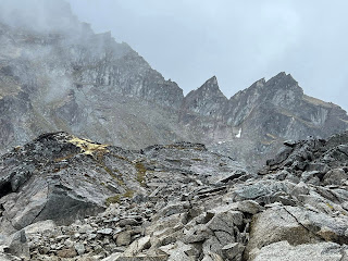
The weather forecast was for some clouds but basically a nice warm sunny day. I was a little skeptical when I stepped out the door and saw the thick overcast. But we drove up to the Reed Lakes Trailhead and hoped that the overcast would burn off. When we reached the Snowbird Trail as it leaves the Reed Lakes Trail, we saw the clouds and fog slowing moving up through the Reed Creek Valley. As I started up the very steep winding trail that heads up to the first ridge toward Snowbird Mine ruins, I noticed that fog was also enveloping the peaks around us. I said to my hiking partners that I thought we were going to get swallowed up by the clouds. And, yes, that is exactly what happened. The higher we got on the trail, the thicker the fog became. The trail itself is often rather difficult to follow. It winds through piles of old mine debris then on up through gigantic boulder piles. It can be difficult to figure out where the trail actually is. Fortunately a couple of our group had been there before and had a good general idea. We had a few small stream crossings and lots of boulder climbing. The farther we climbed the more we figured we were not going to outclimb the clouds and finally reach the glacier and our actual destination, Snowbird Hut. It is an interesting route, winding through sections of large boulders, then areas of good trail through green vegetation sprinkled with blueberries. After several hours we finally climbed the largest boulders to the high ridge that usually gives the first view of Snowbird Glacier. When we arrived we ate lunch and hoped we would see the glacier. We saw a large snowfield that leads to the glacier, but the fog was too thick to see past that. As we pondered whether it was worthwhile to continue on at least another mile, down to the glacier, then up the steep difficult to follow route to the hut, it started to rain. Shelly walked down through the snow to have a look. She returned saying she couldn't see anything out there. At one point, the clouds lifted slightly and we had a short glimpse of the glacier, but it was quickly gone. This is a beautiful hike, and still involved a trek across the glacier then a steep hard to follow boulder climb, so we decided to turn back before we got dangerously wet and the rocks and trail became dangerous and slippery. It was rather disappointing but still a lovely hike. We plan to try again in the next few weeks.


Thursday, August 17, 2023

Lazy Mountain Matanuska Peak Ridge Hike

 Today I hiked the ridge between Lazy Mountain and Matanuska Peak with the Valley Wanderers. We hiked to the 16,500 marker on the Matanuska Peak Trail then hiked up through thick wet brush to the top of the ridge. While pushing through that brush I was thinking it would have been easier to simply hike all the way up Matanuska Peak. I have been wanting to climb it all summer, but haven't found a good day and someone to join me. I'm considering simply packing up to the base of the peak and camping, then going to the summit in the early morning before the afternoon buildup clouds roll in to obscure the view. Today we had spectacular views in all directions. It was a strenuous hike but such a gorgeous sunny day. Just enough wind to keep from getting too hot on the climbing parts. Our high point was 4195 feet.


Tuesday, August 15, 2023

Around Gold Cord Lake

 Today started out as a short hike up to Gold Cord Lake with Mark Simpson. But we started to follow the pieces of trail heading towards the mountains behind the lake. The farther we walked the more we started considering the idea of maybe walking all the way around the lake. This lake is surrounded by huge granite boulders and in many places one wonders if it is even possible to get through them. But we picked our way from rock to rock and once we reached the halfway point, we sure didn't want to backtrack. There is a fairly defined trail for about 3/4 of the way until on the south side we encountered much larger rocks. We scrambled up some moss-covered slopes in between the biggest boulders. But we did finally need to come down through the rocks to reach the trails along the front side of the lake. It was really kind of exciting to finally find our way all the way around the lake. I have seen other people wandering around on the far side in the past, but never knew if it was reasonably possible to go all the way around. It was really fun and very beautiful. I enjoyed seeing the little mountain lake from a totally different perspective. Instead of the usual 2 mile trail we walked 3 miles total. 

The historic Lynch Cabin on the lower part of the trail


View of the lake from the far side


Our route from the GPS on my Apple Watch